Some of the most easily accessible hikes in the San Gabriel Mountains begin in Altadena, at the northern end of Lake Avenue. There are hikes with varying degrees of difficulty, from moderate hikes suitable for beginners looking to get into hiking, to strenuous hikes that can keep you on the trail all day. There are well-travelled popular trails, where you will not lack for company, and there are more adventurous use-trails and routes if you want to challenge yourself. The mountains can put up very beautiful wildflower displays in the spring, or be covered in the snow for some beautiful vistas in the winter. And the trailheads are only a mile from the bus stop!
Transit: A number of LA Metro bus routes end at the intersection of Lake Ave. and Altadena Dr. in Altadena:
[googlemaps https://maps.google.com/maps?f=q&source=s_q&hl=en&geocode=&q=lake+ave+and+altadena+ave&aq=&sll=34.184471,-118.131809&sspn=0.23743,0.289078&ie=UTF8&hq=&hnear=E+Altadena+Dr+%26+Lake+Ave,+Altadena,+California+91001&ll=34.190166,-118.131311&spn=0.007419,0.009034&t=m&z=14&output=embed&w=200&h=160]
- Line 180 from Hollywood. (This is the most convenient route, since the last bus going back downhill is at midnight)
- Line 485 from Downtown LA (weekdays only, express fare from Downtown)
- Lines 267 / 264 from El Monte Station / City of Hope respectively
- Line 256 from Commerce / East LA. This line ends on Lake Ave. at Mendocino St., a couple of blocks south of Altadena Dr.
- All of these bus lines pass through various parts of Pasadena, making this hiking destination easy to access from Pasadena. You can also take the Gold Line to Lake Ave., and transfer to the 180 or the 485.
Bike: The trailheads are about a mile from the bus stop, and a bike can be useful to get to them. However, it is important to know that Lake Avenue is quite steep north of Altadena Drive—it climbs about 500 feet in the last one mile. Alternatively, you can skip the buses altogether, and bike up Lake Avenue from Pasadena, for a workout on the bike.
The Hikes:
Bottom Line: Good "staple" hikes or bike rides for me since I'm in Pasadena, excellent views of the San Gabriel Valley and the entire Los Angeles metropolitan area (all the way out to Catalina Island) on good days, good place for full moon hikes, a lot of history with the remnants of the Mt. Lowe Railway.
Difficulty: Moderate to Strenuous depending on which hike you choose and how far you go. The less-used trails, particularly in Rubio Canyon, can be very treacherous.
Best seasons: Year-round. Beautiful wildflowers in the spring, cool hiking temperatures in winter. Watch out for snow and/or ice above Echo Mountain in the winter, particularly after storms; and hike early in the morning or late in the evening on summer days to avoid the heat. Use-trails and off-trail routes can be slippery after rains, and it is best to avoid them at these times in order to prevent erosion.
Trailheads
Two main trailheads lead to a network of trails up the mountains (there are other trailheads, but not as convenient):
- Cobb Estate / Sam Merrill Trailhead: Cobb Estate is at the northern end of Lake Avenue, where the road ends at the intersection with Loma Alta Drive. To get to the Sam Merrill trail, walk east into Cobb Estate, and continue straight where the estate road turns northwards. There is an old sign that says "Trail" as well as a water fountain, the last water available on the mountain. Once you get to the trail itself, you should see another sign confirming that you are on the right trail:

If you arrive at a large reservoir, you missed the trail and should backtrack to the bend in the road.
- Rubio Canyon Trailhead: The access point into Rubio Canyon is between two houses in a residential neighborhood. From Lake Ave., turn east on Palm Drive, and navigate towards this point on the map:
[googlemaps https://www.google.com/maps/embed?pb=!1m18!1m12!1m3!1d3299.7837611589875!2d-118.12283600000004!3d34.20300099999999!2m3!1f0!2f0!3f0!3m2!1i1024!2i768!4f13.1!3m3!1m2!1s0x80c2c2b79eeab93f%3A0xdac725f0695c69a1!2sRubio+Canyon+Trailhead!5e0!3m2!1sen!2sus!4v1402715662184&w=300&h=225]
The trail begins next to the fence of a house on Rubio Vista Road, watch for a trailhead sign along with a Hazard Area warning.
Hiking destinations and options
Several hiking routes begin at these two trailheads, and it is not the intention of this post to describe them in detail. I'll just point out some interesting destinations, and let you figure out where you want to go! It is your responsibility to better research these routes—they can all be dangerous and may sometimes require scrambling. Do not attempt any of the Rubio Canyon trails if you are an inexperienced hiker or not comfortable with navigation!
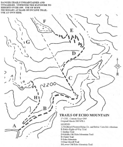
- Echo Mountain: Echo Mountain is the first major destination at 3207', with some pretty cool history about attempts to build a hotel, railroad and observatory, and nature reclaiming the mountain. There are several routes up to Echo mountain, some easier than others. The simplest route is to follow the Sam Merrill Trail from Cobb Estate, a moderate hike that gains 1400' over 2.5 miles. This makes an excellent introduction to moderately difficult hiking for beginners.


You can also hike up to Echo Mountain from the Rubio canyon trailhead, either using the Lower Old Echo Mountain Trail to the Sam Merrill trail, or using the Incline trail (see map below). Both these trails have loose and crumbly soil and rock, and require careful hiking.
-
Inspiration Point: Inspiration Point is the next stop up the mountain at 4500', with several trails leading to it from Echo Mountain. It is a viewpoint from which you can see all the way out to the Pacific Ocean and Catalina island on clear days. My favourite option is to go up Castle Canyon trail (steep, good workout) and come down the Upper Sam Merrill trail (watch out for mountain bikers!) for a nice loop.
There are other routes up to Inspiration Point too, if you want to avoid the crowds on the Sam Merrill trail. From the top of Lake Avenue, you can directly climb the prominent ridge going north, and connect to the Mt. Lowe fire road to Inspiration Point. I believe this is called the Altadena Ridge route. Bear in mind that this involves hiking on a use-trail and scrambling over some steep sections of loose rock.

Another alternative trail to Inspiration point is the Lone Tree / Idlehour trail—see here for details. Muir Peak is the small bump right next to Inspiration Point, not all that special.
- Mount Lowe: If you made it to Inspiration point, and the weather is cool, and you're not really that tired, why not stretch a little more and climb to the summit of Mt. Lowe? Mt. Lowe is the peak immediately north of Inspiration Point, and at 5603', it adds another 1000 feet of elevation for a total elvation gain of 3800' from the trailhead, 4300' from the bus stop. You'll be rewarded with views of Inspiration Point and Los Angeles, as well as the other peaks of the San Gabriels (Mt. Wilson, San Gabriel Peak etc.) to the north. The trail to Mount Lowe turns off about 0.2 miles from Inspiration Point. It was a mildly snowy day when we went, following just one set of footprints in the snow, and it was truly magical.


- Rubio Canyon: Finally, there are a number of cool waterfalls to explore in Rubio Canyon from the Rubio Canyon trailhead. Check out the Arroyo and Foothills Conservancy website and Dan Simpson's blog as starting points for details. The AFC has done, and continues to do, a great job in maintaining trails and looking after the Rubio Canyon area.


There are a number of different hikes, therefore, by choosing different routes going up and coming down. Since you don't have to worry about a parked car, you can go up from one trailhead and come down another.
Wildlife: This area of the San Gabriel mountains receives a lot of foot traffic, and wild animals tend to be shy. There are bears and mountain lions throughout these mountains, but they are not keen on meeting people. I routinely hear owls in Cobb estate at dusk, but wildlife sightings are infrequent. That said, two of my most memorable wildlife sightings have been on the Sam Merrill trail.
On the first occasion, a friend and I hiked up to Echo Mountain at night to watch a total lunar eclipse. We were the first ones up that night, and as we came into view of the remains of the old railway terminal, there was this magnificent stag on the platform in the moonlight, great big horns, silhouetted against the city lights in the background. An image that is etched in my mind.
The second cool sighting was a huge Southern Pacific rattlesnake that made its way across the trail one evening around sunset. It had just had a meal, with a rabbit sized lump along its midsection, and it was in no hurry to cross the trail. I gave it its space, but got good looks at it from 10 feet away for some 3 to 5 minutes as it slowly made its way across. Fantastic.
If you hike at night, you'll sometimes come across groups of school kids mostly up to no good at Cobb estate and the lower reaches of the Sam Merrill trail. Their loud partying and shouting spoils the beauty and solitude of the wilderness, and I disapprove of getting high on nitrous oxide on hiking trails. But this is otherwise a remarkably well-maintained and litter-free area, given the heavy traffic it receives.
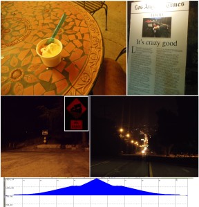
Ice cream bonus: Finally, I think ice cream is a great reward for a nice hike or bike ride. Some people like to celebrate with beer, but beer must be the least tasty idea mankind has ever come up with. Anyway, Lake Avenue also has one of the best gelato places around: Bulgarini gelateria on Altadena Drive at Lake Avenue. Great as the destination for midnight bike rides up the hill, or to grab a couple of scoops of pistachio or their seasonal flavours before getting on the bus going back down the hill.
-N


